|
Nelle righe
che seguono vorrei parlare di APRS, partendo da zero. Spesso, noi
radioamatori tendiamo a dare un po' tutto per scontato...
Un grazie a Michele IW1GFV che mi ha riportato con i piedi per terra!
Di seguito vi riporto una specie di FAQ, sperando di esservi d'aiuto
In the following lines I would like to speak of APRS departing
from zero. Often, OM have the tendency to give everything for
discounted...
Many thanks to Michele IW1GFV that has brought me with the feet on
the earth!
Following I give you a kind of FAQ, hoping to help you.
APRS: cos'è?
APRS: what is it?
APRS è un acronimo che sintetizza le
parole Automatic Position Reporting System. Il protocollo che codifica il
sistema APRS è stato presentato da Bob Bruninga al TAPR/ARRL Digital
Communication Conference nel 1992.
L'APRS è un sistema di comunicazione
digitale fra più ricetrasmettitori che sfrutta uno specifico frame del
protocollo di comunicazione AX25, utilizzato per fare packet, ovvero
comunicazione digitale a pacchetti.
L'APRS non va confuso con il packet, anche
se i segnali scambiati sono praticamente gli stessi.
Rappresenta un'ottima interfaccia fra la ricetrasmittente ed il
localizzatore satellitare GPS (Global Positioning System). Per
approfondimenti alla localizzazione satellitare è possibile consultare la
pagina relativa al
sistema GPS.
Utilizzando il sistema APRS è possibile
trasmettere la propria posizione, messaggi di stato e/o messaggi di testo,
informazioni meteo, e così via. Sul territorio sta crescendo una rete di
ripetitori digitali (digipeaters) che "ripetono" il segnale APRS secondo
regole opportune.
La potenza del sistema è enorme,
specialmente per applicazioni di protezione civile.
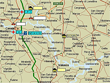
Nell'immagine che segue, riporto un
piccolo esempio di ciò che si potrebbe avere a video del PC.
APRS is an acronym that
synthesizes the words Automatic Position Reporting System.
The protocol that codifies the system APRS has been introduced by
Bob Bruninga to the TAPR/ARRL Digital Communication Conference in
1992.
The aprs is a system of digital communication among more
transceivers that it exploits a specific frame of the protocol of
communication AX25, used for making packet radio.
The aprs must not be confused with packet radio, even if the
exchanged signals are practically the same.
It represents a good interface among the transceiver and the GPS (Global
Positioning System).
Using the system APRS is possible to transmit our position, messages
of state and/or messages of text, meteo information, and so on. On
the territory it is growing a net of digital repeaters (digipeaters)
that "repeat" the signal APRS according to opportune rules.
The power of the system is enormous, especially for applications of
civil protection.
In the following image, you can find an example of APRS video
output.
APRS: cosa serve?
APRS: what do you need?
La domanda è buona! Cosa serve per fare
APRS????
Dobbiamo fare una piccola premessa
scindendo il problema:
- cosa serve per trasmettere la propria posizione
- cosa serve per visualizzare le mappe e le stazioni.
Andiamo con ordine.
Per trasmettere la propria posizione
occorre innanzi tutto conoscerla. Serve quindi un ricevitore satellitare GPS.
Normalmente questi ricevitori dispongono di una uscita seriale per l'interfacciamento
al PC. L'alimentazione, in genere a 5Vdc, viene sempre prelevata dal PC,
attraverso la porta mouse o tastiera PS2, oppure attraverso il connettore
USB.
Quindi, occorre convertire il segnale seriale in uno compatibile con il
protocollo packet. Di soluzioni ne esistono tantissime, ma in genere si
utilizzano delle piccole interfacce denominate TINYTRAK (tipicamente in
versione I oppure III) che si occupano della conversione del segnale.
Il tinytrak è normalmente realizzato con un integrato PIC 16F84 che si
occupa di leggere la seriale, elaborarne i segnali e convertirli in formato
packet, gestendo anche la commutazione in trasmissione del RTX.
Infine, serve un ricetrasmettitore in FM per la trasmissione vera e propria
della propria posizione.
Se, invece, si dispone di apparati Kenwood quali il TH-D7 o il TM-D700 è
sufficiente collegargli il ricevitore GPS, in quanto entrambi dispongono di
TNC (Terminal Node Controller) interno.
Per visualizzare le mappe e le stazioni
il discorso è leggermente diverso...
Iniziamo con il dire che potrebbe non essere necessario utilizzare il GPS in
quanto esistono programmi quali ITALOC che consentono di conoscere
latitudine e longitudine del proprio comune con buona precisione (il
discorso si complica un po' per chi abita in città grosse...).
Per la visualizzazione di mappe e stazioni serve sicuramente un PC, anche di
prestazioni non eccelse. Le mie prime prove sono state effettuate con un
Pentium 150MHz overcloccato a 166MHz con 32 MB di RAM...
Il sistema operativo è una delle tante versioni di Windows, da 98 Second
Edition in poi.
Il programma più utilizzato per fare APRS su PC è sicuramente UI-View di
Roger Barker G4IDE.
Sostanzialmente ne esistono 2 versioni: una versione shareware a 16 bit ed
una versione a 32 bit per la quale occorre registrarsi presso l'autore (al
costo di 10 sterline, pari a circa 16 Euro più 5.16 Euro di vaglia
internazionale).
Per le prime prove va benissimo la versione a 16 bit. Quando si inizia ad
apprezzare le potenzialità del sistema è consigliabile passare alla versione
a 32 bit.
Le mappe sono disponibili in una infinità di siti radioamatoriali; anche
nella mia pagina
download ne potete trovare
qualcuna specifica della mia zona.
Per terminare serve una interfaccia fra il PC e la radio. Se si dispone di
un TNC lo si può utilizzare agevolmente, collegandolo ad una seriale libera
del PC. L'utilizzo di un TNC è consigliabile se si utilizza un PC non
potentissimo (il mio vecchio P166...). E' anche possibile sfruttare la
scheda audio ormai presente in ogni PC, facendole fare tutto il lavoro di
conversione A/D e D/A dei segnali, sfruttando il software di
interfacciamento AGW Packet Engine realizzato da SV2AGW e disponibile
anch'esso in versione shareware.
Sostanzialmente abbiamo ora tutti i pezzi necessari per "assemblare" il
nostro sistema APRS.
Ovviamente se qualcuno volesse soltanto effettuare dell'ascolto per
conoscere un po' meglio il sistema, è sufficiente collegare l'uscita per
l'altoparlante esterno all'ingresso della scheda audio, caricare il software
AGW Packet Engine, il software UI-View ed iniziare a "giocare".
Per il download del software rimando al
sito
del GAL (Gruppo APRS Lombardia).
Per la configurazione della scheda audio si possono consultare le mie pagine
dedicate alla
sperimentazione.
The question is good! What do
you needs making APRS????
We have to make a small premise separating the problem:
- thing serves for transmitting position
- thing serves for visualizing the maps and the stations.
We go with order.
To transmit the position it is necessary first of all to know it. It
serves therefore a GPS receiver.
These receivers normally have a serial exit to be connected to the
PC. The power supply, generally to 5Vdc, is always obtained by the
PC, through the mouse or keyboard plug, or through the USB connector.
Then it it is necessary to convert the serial signal in a signal
compatible with the packet protocol. There are a lot of possible
solutions, but usually it is used a small interface called TINYTRAK
(typically in version I or III).
The tinytrak is normally realized with an integrated PIC 16F84. It
is used to read the serial output of the GPS, to elaborate this
signal and to convert it in packet format, also managing the
commutation in transmission of the RTX.
And finally, you need an FM transceiver for transmitting your
position.
If you use Kenwood radio, such as TH-D7 or TM-D700 it is enough to
connect the GPS receiver, because they have a TNC (Terminal Node
Controller) inside.
To visualize the maps and the stations the way is slightly different...
We begin with to say that it isn't necessary to use the GPS. You can
use a lot of program (similar to the italian ITALOC) that allows you
to know latitude and longitude of your city with good precision.
For the visualization of maps and stations it serves a PC, also of
non sublime performances. My first tests have been effected with a
150MHz Pentium overclocked to 166MHz with 32 MB of RAM...
The operating system is one of the so many versions of Windows,
starting from 98 Second Edition.
The program more used for making APRS on PC is UI-View of Roger
Barker G4IDE.
Substantially it exists two versions of it: a 16 bit shareware
version and a 32 bit version for which registration is needed.
For the first tests it is sufficient the 16 bit version. When you
begun to appreciate the potentialities of the system it is advisable
to pass to the 32 bit version.
The maps are available in an infinity of OM sites; also in my site
you can find someone.
To interface your PC to the transceiver, you need a device called
TNC or a sound card installed in your PC. I prefer to use the TNC,
but the sound card works very fine. The use of a TNC is advisable if
a non powerful PC is used (my old P166). If you use the sound card
as a DA and AD converter, you need the AGW Packet Engine developed
by SV2AGW and available also in shareware version.
Substantially we now have all the necessary pieces "to assemble" our
APRS system.
For the configuration of the sound card you can read my pages in the
experimentation section.
APRS: esistono programmi di supporto
a UI-View?
APRS: do programs of support exist to UI-View?
Sì! Esistono decine di programmi e utility
per UI-View, che consentono di monitorare il traffico, di visualizzare lo
stato delle stazioni, di visualizzare l'instradamento dei segnali fra i vari
digi, di monitorare le stazioni meteorologiche presenti, fornendo grafici
con andamento delle principali grandezze meteo, archivi, ecc.
Come vedete la fantasia può sbizzarrirsi!
Yes! A lot of programs and utilities
exist for UI-View, that allows of monitoring the traffic, to visualize the
state of the stations, to visualize the routing of the signals among the
various digipeaters, of monitoring the meteorological stations, furnishing
graphic of meteorological variables, and so on...
APRS: su quali frequenze si opera?
APRS: on which frequencies it works?
E' ormai diventata convenzionale la
frequenza di 144.800 MHz per la trasmissione di segnali FM per l'APRS.
Trattandosi di comunicazioni digitali, occorre ricordare che la velocità dei
dati è di 1200 bit/secondo.
In all the world it is used the
frequencey 144.800 MHz for the transmission of FM signals for the
APRS.
It is necessary to remember that the baud rate il 1200 bit/seconds.
Per ulteriori
approfondimenti è possibile visitare il sito internet del
GAL (Gruppo APRS Lombardia).
For further close examinations it is possible to
visit the GAL site (APRS Group of Lombardia).
|